
McKinney and Yeti Fires
Maps: Zeke Lunder
Captions: Ryan Stephens
Table of Contents:
- McKinney and Yeti Fire Weather Forecast
- McKinney Fire
- Yeti Fire
McKinney and Yeti Fire Weather Forecast:
—McKinney Fire—
To better understand what’s happening around the fire and in our maps, Click here to watch the Thursday morning August 4 McKinney fire operational update from KNF facebook page.

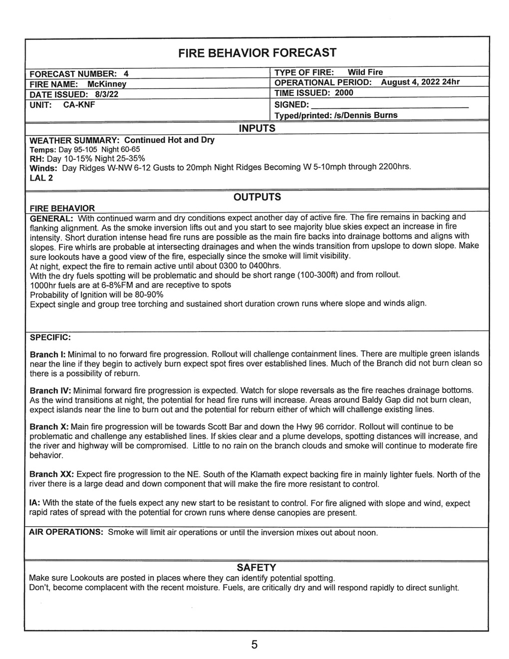
McKinney Fire Behavior Forecast:
McKinney Infrared Lookout Maps:
LOOKOUT MAP KEY: Areas shaded RED are where the fire is most active. Areas shaded YELLOW are where the fire is cooling down.
RED to WHITE perimeter lines represent approximately 24 hours growth as of 9:37pm on August 3.
BLACK lines are dozer lines that may or may not have been completed.
Area shaded in BLUE are recent wildfire perimeters.


Overview of all Ops in Branch V.
A closer look at containment line progress on the south end of the fire.


—Yeti Fire (previously China2)—
MIDDAY UPDATE – 8/4/2022, 2pm.
Noon FIRIS flight shows progression of firing along West Grider Road overnight, and of slopover above China Grade Road.
Color fills are from last night’s IR flight. Red outline is from noon on August 4 FIRIS data.

Firing on west side of fire. Slopover in center of image was lined overnight, per Ops briefing on KNF Facebook page. The aerials show an old road there. Unclear on status of spots to the east.

Firing along the West Grider Road was tied into handline down to bottom of the hill. Solid red fill shows fire’s extent at about 9:45pm, last night.

EARLIER…
We got some nice photos of the Yeti underburning low and slow down to the Klamath river. These photos were taken Yesterday, August 3 around noon and are coming to us from Jamie Allen in Seiad Valley, CA.


To better understand what’s happening around the fire and in our maps, click here to watch the Thursday morning, August 4 Yeti and Alex fire operational update from the KNF Facebook page.

Yeti Fire Behavior Forecast:

Yeti Infrared Lookout Maps:
LOOKOUT MAP KEY: Areas shaded RED are where the fire is most active. Areas shaded YELLOW are where the fire is cooling down.
RED to WHITE perimeter lines represent approximately 25 hours growth as of 10pm last night, August 3rd.
TEAL lines are from 12pm yesterday afternoon, August 3rd.
BLACK lines are dozer lines that may or may not have been completed.
Area shaded in BLUE are recent wildfire perimeters.
TAN fill under the Yeti perimeter is the 1987 China Fire.


***END MCKINNEY AND YETI FIRE