
The Timber Fire in Big Sur’s Ventana Wilderness is entering a critical phase, with extreme weather, rugged terrain, and heavy fuels driving steady westward spread toward Manuel Peak which sits just inland of the Big Sur Valley. It is likely that the fire will get over the ridge, which has very difficult access and a lack of opportunities for good firelines, and back down the west side of the mountains toward Big Sur. Watch our briefing video, below, or scroll down for a long-form analysis of the current situation, including a look at the severity/fire effects of the fire so far.
8/26/2026 Mapping Update:


Our 8/26/2026 Lookout Livestream takes a deep dive into the geography of the Timber Fire, its behavior, ecological effects, and the firefighting strategy moving forward.
The Timber Fire burning in the Ventana Wilderness above Big Sur is entering a dangerous new phase, with extreme heat, critically dry conditions, and rugged terrain all combining to make further spread likely—potentially back toward the heart of Big Sur.
Earlier reporting from 8/25/2026

Over the past day, perimeter mapping shows the fire has grown by roughly 3,000 acres, to around 16,000 acres. All of this growth has been in the backcountry, deep in the Ventana Wilderness. While the front country areas west of Coast Ridge Road and up the Big Sur River to Ventana Camp are largely cooled and contained, the fire’s backcountry flank remains highly active, particularly around Ventana Creek and the Upper Big Sur River.
Most Problematic Fire Movement: From Backcountry Toward Manuel Peak
The Timber Fire crossed the Big Sur River around the 21st of August, and has been making strong, slope-driven runs through the wilderness. In recent days, we’ve seen the fire:
- Burn actively east of Sykes Hot Springs, and up Lion Creek.
- Establish itself into Redwood Creek.
- Spread back to the west, becoming well-established in Ventana Creek.
This westward regression is especially concerning because there is little to stop the fire once it backs down to Ventana Creek and then reverses slope, turning from a backing fire into a head fire running uphill to the west.
Once this happens, the fire has a clear path to:
- Run up the backside of Manuel Peak, and
- Potentially push over the ridge toward Big Sur.
Certain drainages on the west side of Manuel Peak contain enough continuous fuel that, once ignited, the fire could run the length of a drainage in a single afternoon, spotting over the coastal ridge to the slopes above Big Sur.


The Southern Flank
Firefighters built control lines on Partington Ridge early in the incident, and the fire has not moved here for over a week. These is some concern, though, that the fire that is burning freely to the east will push back west and challenge control lines on the Coast Ridge Road. We think this won’t be a major issue unless the fire gets strong east winds. Over time, firefighters are going to need to put fire on the ground off of control lines that head south along Coast Ridge Road – eventually the entire perimeter of the potential control box will need to be fired…

Containment Strategy: Reopening Old Firelines
The current strategy relies heavily on using and reopening control lines from past major fires, especially the 2016 Soberanes Fire and older incidents like the Basin Complex Fire. The overall goal is to build a large “control box” around the Timber Fire using a network of:
- Bulldozer lines and handlines along Manuel Peak and Post Summit
- CORRECTION: We mentioned a potential hand line from Post Summit to Pico Blanco Camp, tying into the rock features on Pico Blanco. We have confirmation from people on the ground that this plan has been abandoned in favor of control lines on the El Sur Ranch and Bixby Mtn.
- Perimeter lines stretching all the way from Bottchers Gap toward Los Padres Dam, south to Arroyo Seco, the Indians Road, and back up the south end of Coast Ridge Road
If the fire eventually fills this entire box before a season-ending rain event, the Timber Fire could reach approximately 135,000 acres.

However, there are some major gaps and challenges to this strategy:
- A critical gap remains between the Big Sur River and the top of Manuel Peak, where terrain is extremely steep and rugged.
- The strategy here is to fire off from Post Summit down to Big Sur via Hopkins Ridge, and then along the base of the slope on the east side of Big Sur.
- The incident command team is in the process of re-opening the legacy lines from Soberanes and other fires.
- Historically, the ridge south of Manuel Peak has not held major fires:
- The Soberanes Fire burned all the way out to Big Sur
- The Basin Fire also burned out to Big Sur
- As mentioned, above, indirect control lines are often not effective unless they are ‘fired’ before the main fire gets there. The sheer volume of work needed to prepare the control box for a 135,000 acre fire is immense (over 70 mile of fireline), and putting fire on the ground across this large of a landscape is a very complicated logistical feat. Firefighters will require favorable weather conditions that are neither too hot, too moist, too windy, not windy enough, to achieve good burnouts.
Given that history, we assess that there is no guarantee the fire will be stopped on Manuel Peak if the Timber Fire makes a strong uphill run out of Ventana Creek, and history suggests the fire will back downhill all the way to developed areas of Big Sur, where firelines have already been prepared. The marine layer will (hopefully) dramatically slow the backing spread of the fire, east of Big Sur.
Weather: Critical Heat, Low Humidity, and Nighttime Winds
The most troubling factor in the coming days is the weather, which is lining up to support continuous, aggressive fire behavior.
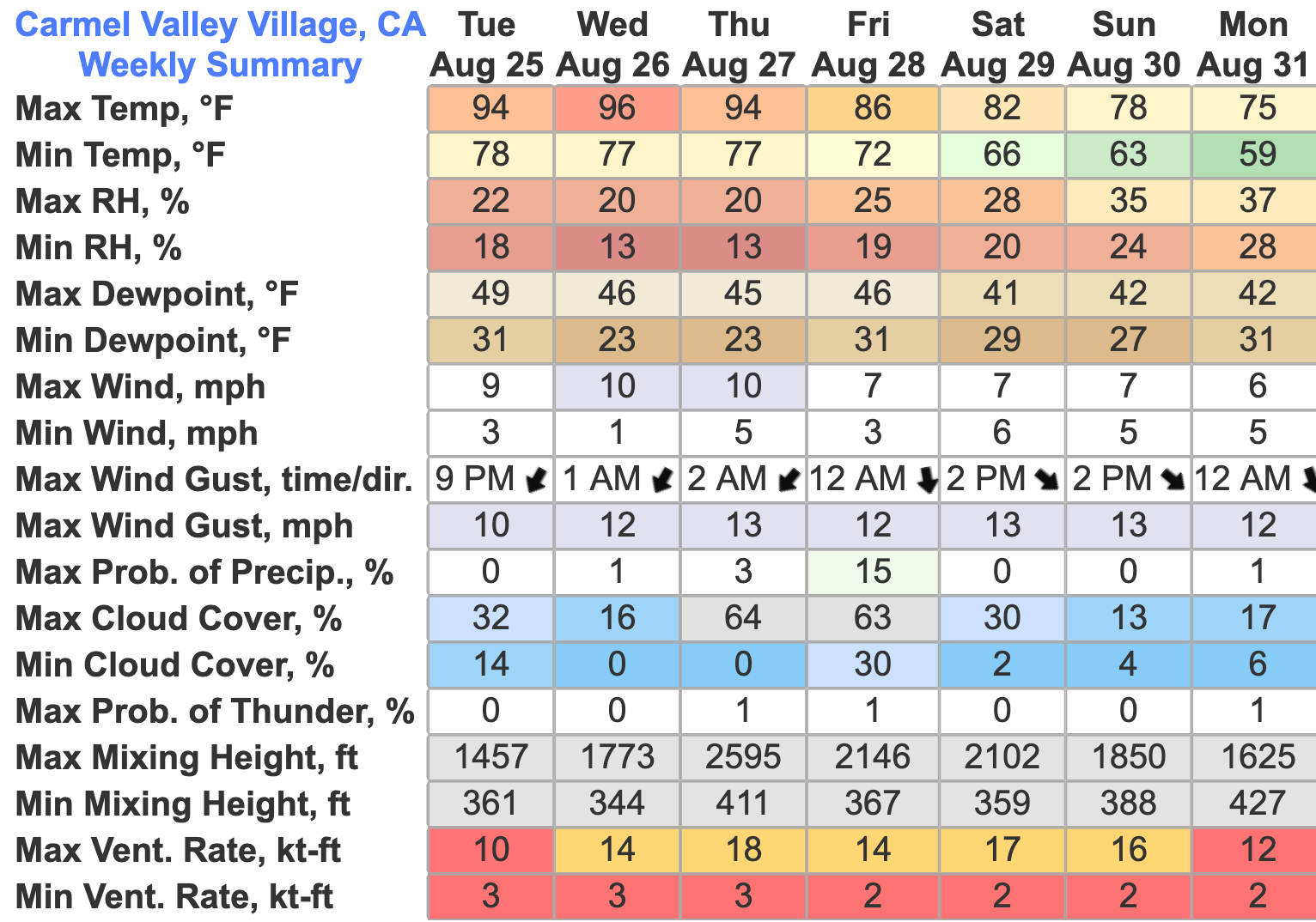
Forecasts for the active fire area near Ventana Creek show:
- Daytime highs of 94–96°F
- Minimum daytime humidity dropping to around 13–18%
- Overnight humidity recovery only in the 20–22% range
- Overnight low temperatures staying around 77–78°F
- Northeast winds at night around 10 mph, with gusts 12–13 mph
-


These are critical fire weather conditions, especially at night. Normally, fires “lay down” after dark as temperatures cool and humidity rises. In this pattern, the fire does not get that respite—it can continue to burn actively through the night, driven by very dry air and persistent winds.
In addition, we are heading into what is often a secondary seasonal peak of fire activity in early September. Fuel data, including the Energy Release Component (ERC), shows that fuel dryness in the region is climbing into roughly the 90th percentile compared to historical records. In other words, fuels are exceptionally dry for this time of year, and the landscape is primed to burn.

Role of the Marine Layer
One of the few moderating influences has been the marine layer. Recently, fog and low clouds have been pushing inland to roughly 1,000–1,200 feet:
- The coastal side of the fire has been largely held near 1,000 feet where marine moisture helps limit spread.
- However, Manuel Peak rises to about 3,500 feet, meaning the upper two-thirds of the slope sits above the marine influence.

Very little marine layer at 8am in Big Sur on 8/25/2026.

This morning, the humidity dropped precipitously in Big Sur and temperatures spiked over 10 degrees warmer than they have been for the past week. If the marine layer is weaker than usual. We could see active fire behavior all the way down to the valley floor, in Big Sur.

If the fire establishes itself on the west side of Manuel Peak, we do not necessarily expect a fast, explosive run straight downhill into Big Sur. Instead, we anticipate a scenario similar to what we’ve seen already in some front country areas:
- The fire backs down gradually toward populated areas, slowing significantly when/if it comes into the marine layer’s influence.
- Progress can be somewhat managed, or slowed with retardant drops and helicopters, but the fire will be difficult to fully suppress until it reaches accessible areas, directly adjacent to the built environment.
- The situation still poses a significant threat and disruption
What This Means for Big Sur
For residents and businesses in and around Big Sur, especially along Highway 1:
- Evacuation warnings may return to evacuation orders if the fire crosses designated trigger points.
- Highway 1 may face renewed closures if fire activity intensifies on the slopes above town or if large firefighting operations resume near the roadway.
- Even without a fast downhill run, the fire is likely to cause ongoing smoke impacts, intermittent access issues, and operational disruptions.
Given the terrain, fuel conditions, forecast weather, and the limited options for direct suppression in the backcountry, we believe it is likely that the Timber Fire will:
- Become firmly established on the front side of Manuel Peak within the next week to week and a half, and
- Generate renewed threats and complications for the Big Sur area, including potential evacuation activity and access restrictions.
We do not know exactly when key thresholds will be crossed—weather shifts, unexpected moisture, or changes in fire behavior could alter the timeline. But based on what we’re seeing now, the most prudent course is to plan for additional disruption, with the hope that changing conditions or effective suppression efforts will limit the fire’s ultimate impact.
Fire Severity
Satellite imagery of the #TimberFire in Big Sur from 8/23/2026 shows that the majority of the burn in areas that were timbered has been low-moderate severity, and many of the redwoods, oaks, and other hardwoods will survive, especially in the riparian areas. Red areas in these images show areas where most of the vegetation is gone (most of the plants/trees here will resprout almost immediately). The red areas were almost all grass, brush/sage, or poison oak, before the fire. Data source: ESA/Sentinel 2


Looking Ahead
We will continue to monitor:
- Daily perimeter growth and fire spread in and around Ventana Creek and the Big Sur River
- The status and effectiveness of reopened Soberanes and Basin Complex lines
- Weather trends, especially any sign of tropical moisture or early-season storms that could dampen fire activity, or cause offshore winds, which could significantly increase the danger the fire poses to areas on the coast.
Fuel conditions and seasonal patterns suggest that the first weeks of September remain a high-risk window for significant fire behavior in the Big Sur region. Our message is simple: plan on it happening—if it doesn’t, we’ll all be relieved; if it does, you won’t be surprised.
We’ll be sharing further analysis, maps, and updates in upcoming coverage as the situation evolves.
AI-Created Summary of 8/26/2026 Lookout Livestream
Overview
Current Fire Behavior and Strategy
- The fire is currently spreading through the Ventana Creek drainage but lacks direct firefighting opportunities due to terrain.
- A primary strategy involves building a “black area” via firing operations between Post Summit and Big Sur.
- Firefighters are also using retardant and dozer lines on Partington Ridge to protect the south end of the fire.
The Proposed Control Box Plan
- The primary containment goal is a 135,000-acre footprint based on old Soberanes, Basin, Kirk, and Marble Cone fire lines.
- Crews are working to reopen old dozer lines from Bottcher’s Gap to Los Padres Dam and along the Coast Ridge Road.
- A “PACE” map outlines contingency plans, ranging from current primary lines to much larger secondary boundaries near Carmel Valley.
Resource Challenges and Staffing Issues
- Several divisions, including Papa, Romeo, and Tango, are currently unstaffed with no equipment assigned.
- Lunder notes that staffing shortages may be due to high demand during planning level five conditions across the country.
- Command is actively working to secure division supervisors and heavy equipment like dozers for these sectors.
Weather Forecasts and Atmospheric Conditions
- Current weather is dominated by a heat dome causing high temperatures around 96 degrees and critically low humidity near 13 percent.
- Forecasters suggest a transition in late August with an incoming trough that may bring moisture or rain by mid-September.
- Stable air is currently helping prevent massive runs, but changing atmospheric stability could alter fire behavior significantly.
Fire Effects and Landscape Impact
- Infrared imagery shows varying burn severities, with many riparian areas and redwood groves showing green vegetation survival.
- Much of the recent burning has been low-severity consumption of 10-year-old brush rather than heavy timber loss.
- Lunder explains how topography, such as north vs. south facing slopes, creates diverse patterns of fire intensity across Big Sur.
Plaskett Fire Assessment
- A separate small fire called the Plaskett Fire recently started near Ragged Point/Lucia in a remote area with little prior burn history.
- Cal Fire utilized an intensive aerial assault to manage this ignition before it could move into heavier timber.
Summary of Future Outlooks
- Success depends on whether crews can complete firing operations before the fire reaches established control lines like Manuel Peak.
- If primary containment fails, firefighters will fall back on contingency lines established during previous major fires like Dolan or Carmel fires in 2021.