
New Mexico Fires
A detailed fire update for May 7th is available here:
https://nmfireinfo.com/2022/05/07/hermits-peak-and-calf-canyon-fires-4/
May 6th, 2022 – Ryan Stephens
- Weather Update
- Calf Canyon/Hermits Peak Fire
- Cerro Pelado Fire
- Bear Trap Fire
- Cooks Peak Fire
- Calf Canyon/Hermits Peak Fire Severity
*Our Lookout fire maps are high resolution. Click the maps to open them in a separate window, there you can zoom and scroll around the map to get a closer look. This is especially helpful to know while viewing our maps on cell phones.

Weather Update
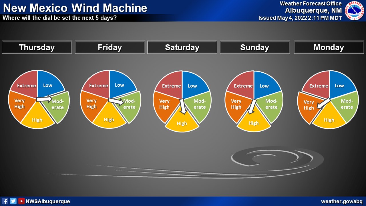
A historic wind storm is on the horizon. Wind is a major influencer in fire behavior. Firefighters doing everything in their power to contain a fire have no control over weather conditions.
During the Santa Fe National Forest’s May 5 daily update, the Incident Meteorologist warned that the upcoming weather event beginning Saturday and lasting well into next week could be “historic.” Not particularly because of the wind speed, though we expect to see gusts upwards of 60 mph beginning Sunday, but because of the duration of the event. Winds are expected to be relentless and continuous for at least 120 hours straight. The high winds will start in Saturday, pushing from the northwest. But by Sunday, the wind will shift and primarily be coming in from the southwest, directing fire spread to the north and east of the fires.
The Santa Fe National Forest posted a video today of the Hermits Peak Incident Meteorologist talking specifically about the weather yesterday, today, tomorrow and beyond. You can watch the video here.
Our weather outlook for today May 6 is relatively favorable. This will give firefighters and civilians one final day to prepare for the upcoming wind storms. It’s important to note that wind events such as what we’re about to experience may cause debris, downed power lines, or trees to fall in the roadways and impede evacuations. Please take this into account BEFORE evacuations are ordered.
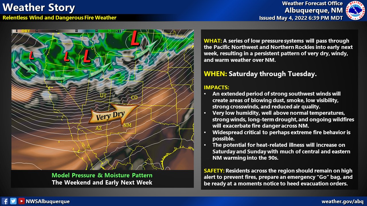
The National Weather Service in Albuquerque has offered an ominous discussion regarding the upcoming series of storms. You can read that discussion here.
Conservative estimates of potential spot fire spread in 50-60 mph wind is in the neighborhood of one mile. That means the fire has increased potential to rapidly progress beyond containment lines in the direction of the wind. It is especially important to consider the surrounding terrain during wind events, particularly when winds are “in alignment” with natural features such as canyons and slopes. A sustained wind event such as what’s forecasted has the potential to deteriorate wildfire conditions rapidly — and that’s putting it mildly.

According to US National Weather Service Albuquerque New Mexico — “Dangerous & potentially historic fire weather conditions are expected this weekend into the middle of next week. A prolonged period of high winds & dry conditions will make our bad situation worse. Take this seriously. Have a plan in place in case of evacuation.”
“A prolonged period of windy conditions is still upcoming starting Saturday through at least the middle of next week. This is bad news as ongoing fires or new ones will have the opportunity to spread rapidly. Be on high alert, and have a go bag in case of evacuation. #NMwx #NMFire pic.twitter.com/JhTv4UQXAl
— NWS Albuquerque (@NWSAlbuquerque) May 5, 2022
Calf Canyon\Hermits Peak
Data for our maps was taken from the infrared flight over the Hermit Peak fire at 2215 hrs last night.
Overview of Calf Canyon\Hermits Peak fire looking north:
MAP KEY: RED perimeter line to WHITE perimeter line shows fire growth in the past 24 hours. ORANGE fill shows intense heat signatures from infrared flight over the fire, this is where the fire is most active. YELLOW fill shows scattered heat, this is where the fire is cooling down. Areas on the map where the RED and WHITE lines overlap is where the fire is generally considered to be less active.

With a system of potentially historic wind events expected to blow in out of the west-southwest, our sights are focused on the east and north sides of the fire.
Be the wind: the following maps walk you around the fire and give you a “winds eye view” of where the fire could potentially push once wind shifts towards the northeast on Sunday.


Today’s Calf Canyon\Hermits Peak Operations Map:

Cerro Pelado Fire
Overview of Cerro Pelado fire looking north:
MAP KEY: RED perimeter line to WHITE perimeter line shows fire growth in the past 24 hours. ORANGE fill shows intense heat signatures from infrared flight over the fire, this is where the fire is most active. YELLOW fill shows scattered heat, this is where the fire is cooling down. Areas on the map where the RED and WHITE lines overlap is where the fire is generally considered to be less active.


Bear Trap Fire
Overview of Bear Trap fire looking north:
MAP KEY: RED perimeter line to WHITE perimeter line shows fire growth in the past 24 hours. ORANGE fill shows intense heat signatures from infrared flight over the fire, this is where the fire is most active. YELLOW fill shows scattered heat, this is where the fire is cooling down. Areas on the map where the RED and WHITE lines overlap is where the fire is generally considered to be less active.

Cooks Peak Fire
Overview of Cooks Peak fire looking north:
MAP KEY: RED perimeter line to WHITE perimeter line shows fire growth in the past 24 hours. ORANGE fill shows intense heat signatures from infrared flight over the fire, this is where the fire is most active. YELLOW fill shows scattered heat, this is where the fire is cooling down. Areas on the map where the RED and WHITE lines overlap is where the fire is generally considered to be less active.

Calf Canyon/Hermits Peak Fire Severity


*** END NEW MEXICO FIRES UPDATE